The Mount Washington Project (formerly known as the Mt. Washington/Connie Hill Property) is located on east-central Vancouver
Island, approximately 25 kilometres due west of Courtenay BC, and extends for 10 kilometres from Constitution Hill and Wolf
Lake west to Mount Washington. The property presently covers 2,421 contiguous hectares (5,980 acres). Access to the property
is by a network of well-maintained paved and gravel mining and logging roads. Electric power and ample water for drilling is
available nearby. Port facilities and year-round accommodations, construction supplies, services and labor are also readily
available in the Campbell River-Courtenay area.
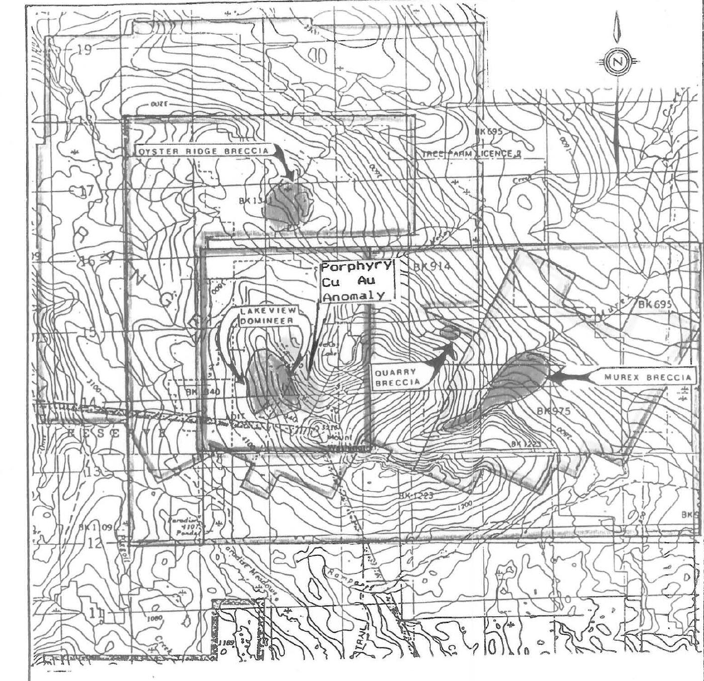
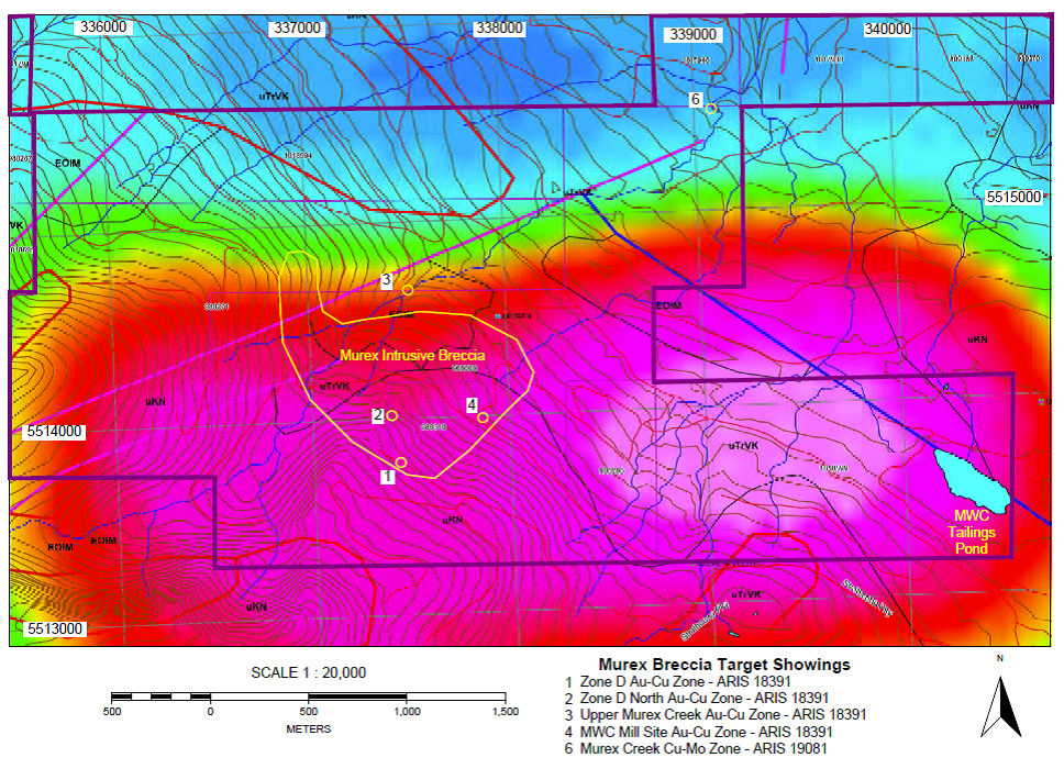
Murex Breccia Zone
The primary target area on the property is currently the Murex Breccia Zone, located approximately 3 km due east of Mount
Washington. As summarized in ,?"the Murex zone represents an area of roughly 700 by 700 metres. The
mineralization is thought to be the result of replacement but also has characteristics in common with porphyry-type deposits.
The zone has been tested by a number of diamond-drill holes. One hole drilled in 1989 cut strong breccias with
pyrrhotite-chalcopyrite mineralization about 30 metres below the surface. A 4 metre section of core assayed 4.08 per cent
copper, 32.91 grams per tonne silver and 6.31 grams per tonne gold (George Cross News Letter #5, January 8, 1990)".
A National Instrument 43-101 Technical Report () filed with the Ministry of Mines in 2013 and authored by Mr. Jacques Houle, P.Eng.,
documents extensive drilling and development on the Mt. Washington project over the course of several decades until 1992, when
the bottom fell out of the metals market and mine development in the area came to virtual halt. Included in the report is an
exhaustive history of development at the Murex Breccia Zone, delineated by outcrop. trench mapping. sampling, and as many as
45 drill holes. A total of five sub-zones have been identified within the Murex deposit, labeled Zones A, B, C, D, and E.
Noteworthy examples from the report show diamond drilling on the Murex by Noranda in 1988 yielded significant intercepts, as
follows:
- NMX-88-17 yielded 0.25m. @ 3.7 g/t gold, 46 g/t silver and 9.7% copper from 196.5 to 197.21 m. from a massive sulphide
vein in Zone A
Later drilling yielded two significant intercepts 100 metres apart stepping out 100-200 metres east of a 1986 drill hole
cluster in the D Zone, as follows:
- NMX-89-25 yielded 4.0 m. @ 6.5 g/t gold, 30 g/t silver and 4.1% copper from 29 to 33m., including: 1.0 m. @ 21 g/t
gold, 71 g/t silver and 9.3% copper from 29 to 30 m. in a massive sulphide vein in basalt with pyrrhotite, chalcopyrite and
pyrite
- NMX-89-26 yielded 6.5 m. @ 0.23 g/t gold, 7.3 g/t silver and 1.1% copper from 16.2 to 22.7 m. in a siliceous basaltic
breccia with pyrrhotite and chalcopyrite
In his NI 43-101 report Mr. Houle states his opinion that "underground, steeply-dipping, bulk mineable, clustered,
breccia
deposits
totaling 100 million tonnes @ 1 g/t gold, 5 g/t silver, 0.50% copper, 0.01% molybdenum, 5 g/t tellurium and 0.5% arsenic"
represents a reasonable exploration target model that can be used as a starting point. From this the Company believes that
the Murex and Oyster (described below) breccia deposits combined represent a potential in-situ resource of at least 200
million tonnes @ 1
g/t gold, 5 g/t silver, 0.50% copper, 0.01% molybdenum, and 5 g/t tellurium, especially when other similar breccia
deposits known to be hosted on the property are factored in.
Upon
review of historical aeromagnetic surveys of the Murex Breccia area, the Company has staked additional ground to the
south and east of the Murex where several additional breccia bodies have been discovered over a broad area, and where a large
aeromagnetic high has been determined to be centered on the property. The newly staked ground now covers the entire magnetic
anomaly, which is approximately 1.5 kilometers in length and 1 kilometer in width. All known copper-gold-silver mineralization
at the Murex contains pyrrhotite and is magnetic, suggesting that the magnetic anomaly may indicate the presence of additional
mineralization.
Oyster Breccia Zone
Another target on the property is the Oyster () Breccia Zone located approximately 3 km
north of Mount
Washington. It has been mapped to be approximately 400 metres in diameter, and is estimated to be at least 184 metres deep.
The MINFILE summary and reports that a grab sample of silicified fault breccia
assayed 14.50
grams per tonne gold,
31.88 grams per tonne silver, 1.04% lead and 0.05% zinc. A 43 centimetre section of core assayed 2.78 grams per tonne gold,
6.86 grams per tonne silver, and 0.07% copper. A more recent report from 2013 () discusses the Oyster
Breccia Zone at length, and documents that it has been delineated by outcrop and trench mapping and sampling, and 9 drill
holes.
Wolf Lake Zones
The Wolf Lake area is in the Connie Hill section of the property northeast of
Mount Washington and includes two gold-bearing sulphide vein showings known as the Road Zone and the Bluff Zone. As
documented in published in 2005 and authored by Mr.
James Laird and Mr. Greg
Thomson, P. Geo.,
these gold-bearing sulphide veins are hosted within shallow east-dipping fracture zones or detachment faults in basalt flows
of the Karmutsen Formation, and are proximal to northwest trending fault zones and Tertiary intrusives. It is believed that
there is a good potential for discovering more high-grade gold zones and of extending the known zones. The Road Zone yielded
grab sample assays of 21.94 grams per tonne gold, 30.86 grams per tonne silver, and 0.66 per cent copper from quartz-sulphide
vein rubble, documented in by Carl Verley and C.J. Westerman in
1986. The
Bluff Zone yielded grab
sample assays up to 76 grams (2.44 ounces) per tonne gold in outcrop grab samples from a quartz-sulphide vein, documented in
by W. Geiger in 2004.
Above Wolf Lake and below Constitution Hill lies an additional showing known as the Lupus zone, which
has assayed up to 2.7 ounces per ton gold and 5.7
ounces per ton silver. Due west of Wolf Lake and halfway to Mt. Washington is the Ideal Zone, which runs along Murex Creek to
the northern border of the property. According to BC Assessment Report
19081, prospecting activities on the Ideal claims has resulted in chip samples assaying as high as 4.35 oz/t gold and 2.7 oz/t
silver.
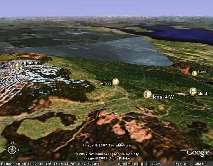
Domineer Vein
The Company?s claim area covers a significant portion of the adjacent Domineer gold vein deposit (), including
the Lakeview-Domineer portal excavated by the previous operator in 1987-88 on western slope of Mount Washington. The
historical resource estimate (not NI 43-101 compliant) of the Domineer has previously been reported as 550,298 tonnes @ 6.75
g/t gold, 32.23 g/t silver and 0.57% copper.
In September 2009, a 168 metric ton bulk sample was extracted near the Domineer portal by the previous operator from an
area
entirely within the Company?s present claim area. The average grade of this 168 tonne bulk sample assayed 51.53 grams
(1.65
ounces) per tonne gold, 88.02 grams (2.83 ounces) per tonne silver, and over 1% copper (). The
bulk sample was taken from within the area of the Domineer historical resource estimate. An additional 6,000 tonnes of ore is
presently stockpiled adjacent to the bulk sample location.
Mt. Washington Copper Mine Tailings
As the direct result of staking additional claims to the east of the Murex deposit, the Company has gained control of a
tailings pond formerly used and abandoned by the Mt. Washington Copper Mine when it was in operation in the 1960?s. In 2014,
Mr. Jacques Houle, P.Eng, assessed these tailings in his on the Mount Washington property and reported that, ?"
Overall the values are relatively consistent throughout the tailings dam, and show good correlation amongst gold,
silver, arsenic, copper, molybdenum, tellurium, iron and sulphur. The metals ofpotential economic interest in the
tailings dam include copper, gold, silver and possibly arsenic, tellurium and/or molybdenum, which could have combined
in-situ values of up to C$5 million using current metal prices.".
The 2014 NI 43-101 Technical Report includes a NI 43-101 and CIM compliant resource estimate on the Mt. Washington Tailings.
This tailings resource estimate, within the indicated and inferred
categories as specified by NI 43-101, totals 325,400 tonnes, of which 241,625 tonnes @ 0.119 g/t gold, 5.68 g/t silver, 0.098%
copper, 8.26 g/t tellurium are indicated mineral resources, and 83,775 tonnes @ 0.119 g/t gold, 5.68 g/t silver, 0.098%
copper, 8.26 g/t tellurium are inferred mineral resources.
The Company
plans to study the economic feasibility of processing the tailings to recover these metals as a source of near-term revenue.
Sources:
BC Ministry of Mines MINFILE No ,
,
,
,
,