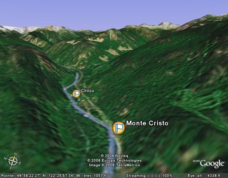
The Monte Cristo and Chilco Properties (collectively referred to as the Monte Cristo
Property) are located in a wide section of the
Lillooet River Valley, approximately 31 kilometers
northwest of the north end of Harrison Lake, BC, and comprise three contiguous staked claims covering approximately 4
kilometers of placer resources along the Lillooet River. Historical assessment of the mineralization of the property describes
precious metal bearing sands that cover a 400 to 800 meter wide section of the
Lillooet River valley. These post-Pleistocene sands are said to contain gold and platinum in submicron sized particles. As
recorded by
the BC Ministry of Mines MINFILE No
and
,
the sands are estimated to contain inferred reserves of
22.7
million tonnes down to a depth of 30 meters, and that a 1.4 kilogram sample of sand, taken at least a meter below surface,
assayed 2.47 grams per tonne gold, 4.80 grams per tonne silver, 2.77 grams per tonne platinum, and 2.71 grams per tonne
palladium.
On February 14, 2012, our JV partner, Devlin's Bench Mining Ltd and P. Wright Contracting Ltd (“PWC”) began an exploration and
sampling program on the Monte Cristo property under the supervision of Ms. Agathe Bernard, B.Sc.. The initial goal of the
work program was to verify the presence of submicron size metals in the sand material along the Lillooet River, which was
previously indicated by work conducted in 1970 by G.L. Kirwin, B.Sc., and J.M. Ashton, P.Eng., as documented in . Instead, the crew unexpectedly found an abundance of visible gold,
with some particles as large as one millimeter.
In her initial report from the field, Ms. Bernard stated, "The first round of soil sampling was exceptionally promising,
showing visible gold flakes in 10 out of 17 samples collected. Most of the samples consisted of 60-90% fine to medium grained
dark gray sand, with 10-30% sub angular light gray fine gravel. Most of the darker fraction correlated with high magnetite
concentration, which is a favorable indication for gold accumulation at the site and is almost invariably present in placer
gold deposits."
The first 17 samples of black sand were concentrated on site using a Keen concentrator and reduced in volume by
approximately 20 to 1000 times to concentrate the fine part of the sample. The concentration was supervised by Ms. Bernard,
and the samples were sent to ALS Labs in Vancouver for analysis. The assay results are reported
as follows:
| SAMPLE | Weight | Au | Au | Ag | Ag | Pt | Pd |
|---|
| DESCRIPTION | kg | g/t | g/t (diluted)** |
g/t
| g/t (diluted)** | g/t | g/t |
|---|
| PS17-120216 | 0.12 | 75.30 | 3.77 | 20.20
| 1.01 | nil | 0.003 |
| PS01-120215 | 0.04 | NSS* | NSS | NSS
| NSS | NSS | NSS |
| PS02-120215 | 0.06 | 79.80 | 3.99 | 0.06
| 0.00 | nil | 0.002 |
| PS03-120215 | 0.04 | 71.70 | 3.59 | nil
| nil | nil | 0.001 |
| PS04-120215 | 0.08 | 5.66 | 0.28 | 23.00
| 1.15 | 0.012 | 0.005 |
| PS05-120215 | 0.16 | 3.32 | 0.17 | 1.84
| 0.09 | nil | 0.003 |
| PS06-120215 | 0.12 | 27.40 | 1.37 | nil
| nil | nil | 0.003 |
| PS07-120215 | 0.02 | 65.30 | 3.27 | 2.18
| 0.11 | nil | 0.006 |
| PS08-120215 | 0.02 | 71.30 | 3.57 | nil
| nil | nil | 0.004 |
| PS09-120215 | 0.08 | 9.47 | 0.47 | 4.13
| 0.21 | nil | 0.002 |
| PS10-120215 | 0.06 | 0.76 | 0.04 | 0.09
| 0.00 | nil | 0.003 |
| PS11-120215 | 0.08 | 1.76 | 0.09 | 0.24
| 0.01 | 0.005 | 0.004 |
| PS12-120216 | 0.14 | 112.50 | 5.63 | nil
| nil | nil | nil |
| PS13-120516 | 0.04 | 60.80 | 3.04 | nil
| nil | nil | 0.003 |
| PS14-120216 | 0.06 | 8.94 | 0.45 | nil
| nil | 0.067 | 0.004 |
| PS15-120516 | 0.1 | 114.00 | 5.70 |
nil
| nil | nil | nil |
| PS16-120216 | 0.08 | 74.80 | 3.74 |
65.10
| 3.26 | nil | nil |
* NSS is non-sufficient sample size
** As the samples were concentrated, only the very fine and heavy particulate were analyzed.
This magnifies the values from real concentration 20 to 1000 times. The estimated diluted values
indicate what would be expected from a raw bank cubic yard of material prior to concentration
processing.
The Company notes that metal values in placer deposits often increase substantially with increase in depth towards bedrock,
which in the case of the Monte Cristo is expected to be well over 100 feet below the surface. These assay results from
near-surface samples are therefore considered quite significant.
Historical Assessment
As reported in BC Ministry of Mines Assessment Report 2589 in 1970, "An estimated 25 million tons of
alluvial sand underlie the property to a depth of 100 feet from the surface, and although depth of the sands is unknown at
this point, indications are that this figure can be increased substantially". The report goes on to say that "precious
metal
values persist to a depth of 100 feet and, in fact, values increase with increasing depth". Another section of the same
report postulates that probable reserves are 50 million tons. The assessment report can be accessed directly at
The following are among the formal conclusions stated by G.L. Kirwin, B.Sc., and J.M. Ashton, P.Eng., the geologists who
authored and certified the Assessment
Report:
- That silver, gold, platinum, and allied metals exist in submicron size particles along with the possibility of sponge
iron in economic proportion and values in the raw sand of the Lillooet River area.
- That many producing mines in the world today derive source from submicron size metals in sand material.
- That metal values are reasonably consistent throughout the sand having been derived from a common source and deposited
under similar conditions, and thus it is highly probable the subject property contains vast quantities of precious metals.
- That original samples show very low grade gold values, while more recent findings show an ounce of gold per ton from
many assays.
- That metal values increase substantially with increase in depth.
- That sand is alluvial, not glacial, indicating full contributions of metals throughout.
- That sands are amenable to open cut operations in an area of easy access with abundant water supply and source of
electric power with direct access to Pacific Ocean ports.
- That a probable 50 million tons of sand to depth 100 feet from surface underlie the Chilco property. Inferred
faulting adds further depth potential.
The report closes with the following statement:
"The depth of alluvium is unknown at this time. However, as the Lillooet River occupies a probable fault zone, potential
for
a deep alluvium deposit exists. Samples have been taken as deep as 130 feet elsewhere along the River without encountering
bedrock. As concentrations of metals in alluvial deposits normally increase with depth reaching a maximum on or close to
underlying bedrock, it becomes significant that values were obtained near surface. Deeper sampling would probably yield
higher metal value."