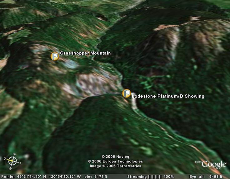
The Tulameen Platinum Project is located below Grasshopper Mountain along a 4.5 km stretch of the Tulameen River and Britton
Creek, near the village of Tulameen and approximately 22 km west-northwest on a straight line from Princeton, BC.
During the late 1800?s, the Tulameen District was the most important producer of platinum in North America.
The Tulameen Platinum Project covers a sizeable part of the dunite core of the ultramafic unit (Alaskan-type) that hosts
platinum, iridium, rhodium and osmium mineralization, and which is often accompanied by chromite and magnetite. It is this
part of the dunite core that has been eroded by the Tulameen River over time and resulted in the release of most of the 20,000
ounces platinum that had been historically mined by placer operations along the Tulameen River and its tributaries. It is thus
our belief that the Company?s Tulameen Platinum Project property hosts the source of most of the historical placer platinum
production in the Tulameen District.
Previous drilling and assays of drill core and chip samples in the area of the Company's "D" claims are documented to have
returned consistently significant platinum values. BC Assessment Report 27009 filed with British Columbia in 2002 describes a
channel sample that returned an assay of 7.78 grams per tonne platinum over 3.5 metres, including 10.17 grams per tonne
platinum across 2.0 metres in chromitiferous dunite. Assay results for chromium were reported to be very high, ranging from
8.67% to 24.97% chromium. In two other zones, the best samples ran 15 grams per tonne platinum in one zone, while results
from diamond drill core analysis in the second zone returned platinum values of 30.89 grams per tonne over 3.05 metres. In
addition, sampling of two historic quarries obtained values ranging from 8 to 64 grams (2.06 ounces) per tonne platinum (BC
Assessment Report 27009, pages 19-25).
The northern portion of the property features several other known platinum-bearing zones. The Ridge Zone (MINFILE 092HNE207)
is a platinum-chromite showing that outcrops along a northwest-trending ridge on the southern slopes of Grasshopper Mountain.
According to BC Assessment Report 17170, samples from the Ridge Zone has assayed up to 1.45 grams per tonne platinum. This
zone has a strike length of 150 metres and a width of 50 metres, with an average assay of 0.55 grams per tonne platinum. The
Ridge Zone connects with two adjacent platinum-chromite occurrences known as the Creek Zone and the South Zone. Samples
collected from the South Zone, which has a strike length of approximately one kilometer, assayed up to 1.4 grams per tonne
platinum. In between the Ridge Zone and the South Zone, the Creek Zone assayed up to 4.4 grams per tonne platinum (Newmont
Exploration). The Creek Zone has a strike length measuring 600 metres (0.37 miles) long and a width of 60 metres.
In 2009, an assessment on an adjacent claim near Olivine Mountain yielded assays as high as 26.94 and 15.97 grams per tonne
platinum from samples taken within 100 metres of the Company?s claim boundary (AR 28750). The samples had been collected from
an extension of the platiniferous dunite rocks that extend south from Olivine Mountain.
The H&H showing on Hines Creek lies approximately 3 kilometres due east of the main zones. According to MINFILE 092HNE205, a
grab sample from the H&H analyzed 3.6% copper, 0.066 grams per tonne gold, 17.1 grams per tonne silver, 0.247 grams per tonne
platinum, and 0.730 grams per tonne palladium (Assessment Report 17280, page 9, sample W461). A quartz vein up to 10
centimetres wide outcrops 50 metres to the south. A grab sample of this vein assayed 0.810 grams per tonne gold and 0.025
grams per tonne platinum (BC Assessment Report 17280, page 9, sample W637).
Olivine Resource & Opportunity
In addition to the well-established evidence of extensive Platinum Group Metals (PGM) mineralization on the property, the
Company notes that the ground covered by the Tulameen Platinum Project is believed to also host a 15 million tonne
drill-delineated historical resource of olivine. An industrial mineral, olivine is a magnesium iron silicate that is also
known as peridot and chrysolite. As documented in MINFILE 092HNE189 and the aforementioned BC Assessment Report 27009, the
resource estimate for the Olivine deposit was initially compiled in 1989 by Dia Met Minerals Ltd., the company led by Charles
Fipke that discovered the first diamond mine in North America. The reports states, "The industrial mineral potential for
olivine was evaluated by diamond drilling in an area located immediately northeast of the confluence of the Tulameen River and
Britton Creek by Dia Met Minerals during the period from 1986 to 1989. Dia Met re-sampled an area recognized as having
potential for olivine from the CANMET study, and on the basis of these results, thirty-one (31) percussion drill holes
totaling 4,626 feet were completed. The drill core was submitted for LOI (loss on ignition) tests. Dia Met outlined a zone
containing 15 million tonnes in the category of geologically indicated reserve, including marginal grade, to a depth of 170
meters, with a surface dimension of 105 meters by 270 meters along the north side of the Tulameen River within the dunite core
of the Tulameen complex." The Company notes that the Dia Met drilling has not yet been verified since the Company acquired
the
property. It is therefore considered a historical estimate and it should not be relied upon. The Company also reiterates that
the Tulameen Platinum Project property covers a sizeable part of the dunite core of the Tulameen Ultramafic complex, and to
date only a small portion of it has been assessed for its olivine content. As such, it is expected that additional deposits
of commercial grade olivine are yet to be defined upon further exploration and evaluation.
Olivine is used in foundries, refractories, sand blasting, soil conditioning and heat storage units, and sells for $50 to $100
per ton, depending on the grade. More importantly, and of great interest to the Company, the olivine mineralization derived
from the dunites is known to also have potential application as raw feed for mineral CO2 sequestration to help moderate global
warming by slowing the growth of carbon emissions in the atmosphere. In the global carbon market, each ton of carbon
sequestered is called a carbon credit. Using sequestration, companies can buy or generate these credits, which are then sold
or traded by companies to offset their own carbon dioxide (CO2) emissions. The Company continues to research this potential
new opportunity to take advantage of the carbon credit market, and will report further findings and developments as we proceed
forward.
Sources: , ,
,
,
,
,
,