Brett West/Bouleau Creek Gold () is a road-accessible property that
covers 2,347 acres located 26 kilometres west of
Vernon, BC. The
property features gold and silver mineralization over an area of approximately 1,000 by 600 metres, and is adjacent to the
Brett Gold project () where 11,970 tonnes grading 39.12
grams per tonne gold have been previously
indicated by surface
drilling and underground work.
The Southern zone of the property below Bouleau Creek features gold and silver mineralization over an area of approximately
1,000 by 600 metres. Historical assays documented in are reported to yield up to 34 grams
(1.09
ounces) per tonne gold and 286 grams (9.19 ounces) per tonne silver. The Northern Zone above Bouleau Creek includes the
Siwash prospect (). The Siwash extends over an area of
gold and silver mineralization
measuring 3,000 by 750
metres. Assays are documented to yield up to 5.55 grams per tonne gold and 16.6 grams per tonne silver ().
The Company has also staked additional claims consisting of 2,552 acres that cover the Gold Star showing ()
immediately to the west of the Brett Gold property, and to within 500 meters of the main Brett Gold deposit. While these
claims are not contiguous with the rest of the Bouleau Creek property, the Company considers these claims to be part of the
project area, and are referred to as the Western Zone, or Brett West. Brett Gold is currently owned and operated by Running
Fox Resources Corp.
In October 2011, a comprehensive pilot geochemical program of the Bouleau Creek Gold property was conducted on behalf of the
Company
by
Billiken Gold Ltd. of Enderby, BC, utilizing Heavy Mineral Concentrates ("HMC") methodology. The program was commenced on
October 10, 2011, and concluded on November 30, 2011. Over 2300 pounds of sample material was collected, and subsequently
processed and cataloged into 36 samples. A photo of a gold nugget from sample NB-60 is shown
below, followed by the assay results. This sample came from a highly altered area in the Western Zone that has geological
similarities to the Brett occurrence. In addition to the high grade, the gold particles in this sample are pristine, angular
in shape, and with sharp edges that suggest they are “low transport gold” and have not traveled very far. This further
suggests potential for a lode gold deposit close by.
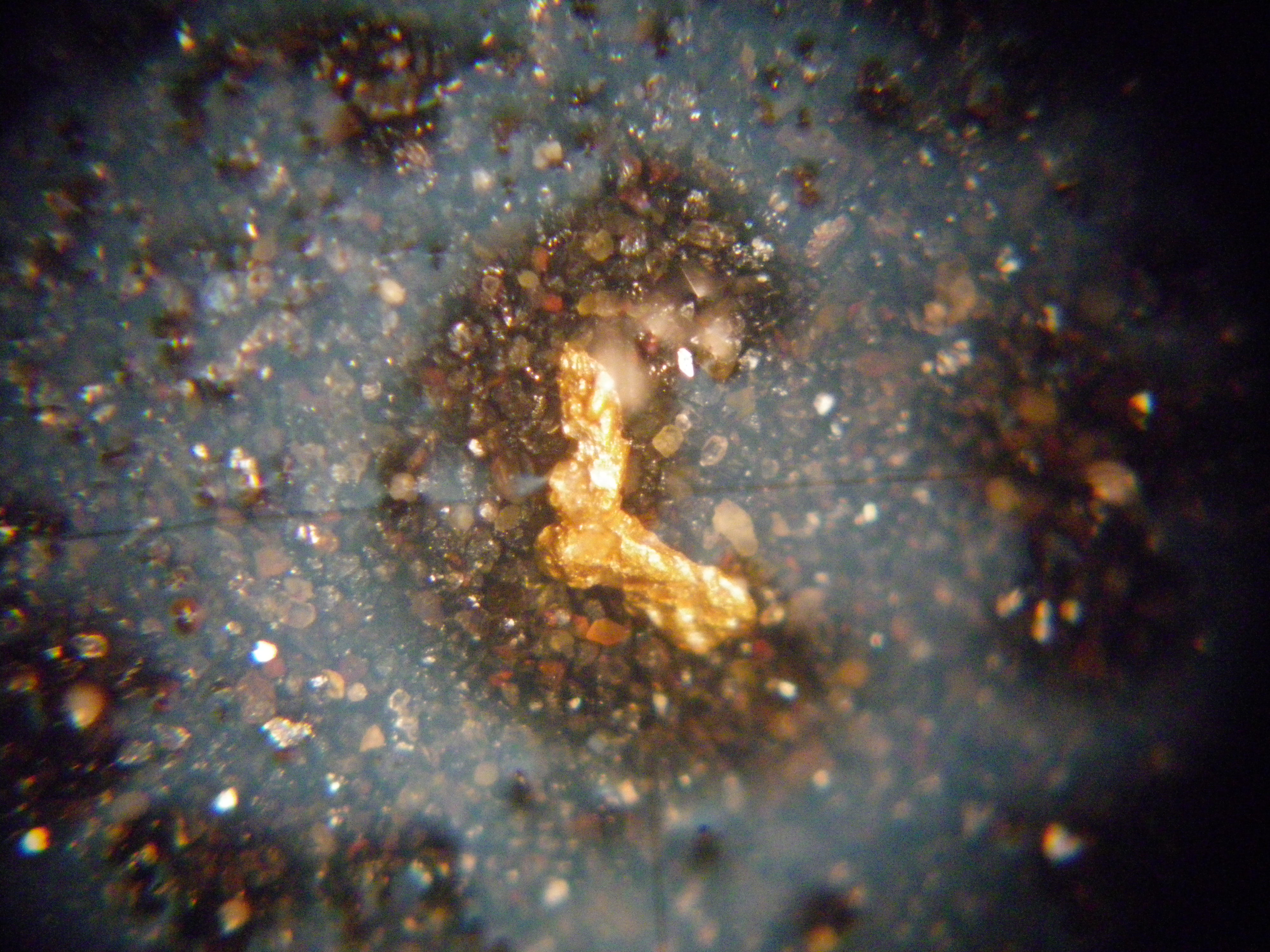
Gold nugget from the Western Zone found during 2011 geochemical survey.
| SAMPLE | Rcvd Wt. | Au |
|---|
| DESCRIPTION | kg | ppm |
|---|
| NB-35 | 0.12 | 0.475 |
| NB-36 | 0.12 | 0.558 |
| NB-37 | 0.12 | 0.177 |
| NB-38 | 0.10 | 0.377 |
| NB-39 | 0.12 | 0.301 |
| NB-40 | 0.10 | 1.82 |
| NB-41 | 0.10 | 0.223 |
| NB-42 | 0.12 | <0.005 |
| NB-43 | 0.12 | 0.048 |
| NB-44 | 0.12 | 0.131 |
| NB-45 | 0.12 | 0.032 |
| NB-46 | 0.10 | 0.007 |
| NB-47 | 0.12 | 0.145 |
| NB-48 | 0.12 | 0.123 |
| NB-49 | 0.12 | 0.507 |
| NB-50 | 0.12 | 0.369 |
| NB-51 | 0.12 | 0.322 |
| NB-52 | 0.10 | 0.03 |
| NB-53 | 0.12 | 0.864 |
| NB-54 | 0.12 | 0.256 |
| NB-55 | 0.12 | 0.407 |
| NB-56 | 0.12 | 0.529 |
| NB-57 | 0.10 | 0.826 |
| NB-58 | 0.12 | 2.09 |
| NB-60* | 0.56 | 95.6 |
| NB-61 | 0.10 | 0.097 |
| NB-62 | 0.10 | 0.455 |
| NB-63 | 0.12 | 0.212 |
| NB-64 | 0.50 | <0.005 |
| NB-65 | 0.54 | <0.005 |
| NB-66 | 0.10 | 0.192 |
| NB-67 | 0.12 | 0.035 |
| NB-68 | 0.12 | 0.335 |
| NB-69 | 0.12 | 0.333 |
| NB-70 | 0.12 | 0.346 |
| NB-71 | 0.12 | 0.312 |
*All of the samples were analyzed by conventional fire assay (Au-AA23), with the exception of sample NB-60. Due to the
presence of visible gold, a metallic screen assay (Au-SCR21) was performed on sample NB-60, where the final prepared pulp is
passed through a 100 micron (Tyler 150 mesh) stainless steel screen to separate the oversize fractions. Any +100 micron
material remaining on the screen is retained and analyzed in its entirety by fire assay with gravimetric finish and reported
as the Au(+)fraction result, which for sample NB-60 was reported as 95.6 grams (3.07 ounces) per tonne gold. The
Au(-)fraction (minus the oversize fractions) assayed 0.24 g/t gold, for a total of 0.77 g/t gold when all fractions were
combined and averaged. Excluding the nugget effect from sample NB-60, the average fire assay of all 36 samples came in at 0.37
g/t gold, including two assays of 2.09 g/t and 1.82 g/t gold, respectively.
During the 2013 field season, a second HMC program was commenced on behalf of the Company by Billiken. This program was
designed to follow up on the previous findings along trend, and to further evaluate the Company’s newly acquired claims
adjacent to the alteration zone and the area where sample NB-60 was found during the 2011 sampling program. This year’s
program was concluded in July 2013 with 46 samples collected. These samples were subsequently processed and catalogued prior
to shipment to ALS Chemex in Vancouver for analysis. Mr. Murray Morrison, B.Sc. Geology, consulted on the project and
assisted Billiken in a detailed megascopic examination of all the samples. Mr. Morrison has more than 30 years of experience
in the geological stratigraphy of the region, with a particular focus on the area bounded by Whiteman Creek area where the
Brett West property is located.. Mr. Morrison and Gene Dodd, President of Billiken, returned to the property site earlier
this month and located an as yet undiscovered alteration zone up slope and up ice from these recent high gold values. Further
work will be required to determine if this newly discovered alteration zone is the cause of the highly anomalous gold assays.
The 2013 HMC program has resulted in an expansion and further delineation of the alteration zone found in 2011, and the
discovery of a completely new and previously undiscovered target area about 400 metres west of where sample NB-60 was taken.
The results of this year’s HMC program are extremely positive and encouraging. At least 5 samples (NB-106, NB-107, NB-126,
NB-137, and NB-138) confirmed and further delineated the presence of highly anomalous gold particles in the soil upslope from
both NB-60 and the large alteration zone discovered during the initial HMC program in 2011. The recently concluded 2013 HMC
project produced assays as high as 9.75 g/t (sample NB-137) from the original target area. New and very positive results
downslope from the newly discovered alteration zone, about 400m west and upslope from NB-60, produced high gold values from
three samples; NB-126 (8.0 g/t), NB-163 (2.29 g/t), and NB-164 (2.53 g/t). These samples were all taken very close together
and point to this new target area upslope. Further sampling is planned for next year to locate the origin of this gold
dispersal plume.
The exceptional assay results from the new discovery zone also correlate with Mr. Morrison’s pick (NB-164) as the most
promising of all the rocks found in the 46 sluice reject samples. This accomplishment of Mr. Morrison’s is indeed a testament
to his ability to spot gold bearing rocks in this environment. Of the 14 sluice reject samples (rock fragments) analyzed,
NB-164 gave the highest value by quite a margin: 0.102 g/t. This indicates that the angular vein material and/or rock
fragments in the sample are gold bearing and appear to be from a source area very close by.
Historical work
Geological mapping and rock
sampling conducted in 1991 by Inco
Exploration and detailed in found
two types of quartz veins with anomalous gold and silver on the Bouleau Property. These were described as an older vein type,
generally with less than 500 ppb gold, and a younger "higher grade" vein type which contains up to 34 grams (1.09 ounces) per
tonne gold and 286 grams (9.19 ounces) per tonne silver. The report went on to state that despite the high number of
anomalous veins it was concluded that the veins were subeconomic and not worthy of follow-up.
In 2002, a new vein was discovered during a survey by Solomon Resources. A company report documented that “Work conducted
during this examination included locating a new vein occurrence and sampling the Zone 7 vein. The veins are generally widely
spaced (>20m), narrow (0.1m - 0.5m) and limited in strike length (<10m). However, a notable lack of follow-up trenching and
detailed prospecting has been conducted previously in the main showing areas. Specifically in the Zone 7 area where one of the
strongest veins is reported, no attempt has been made to expose the on-strike extensions of the vein.”
Results from the 2002 sampling program yielded up to 34.4 grams per tonne gold and 158 grams per tonne silver, including the
following assays:
| Sample | Descriptions | Au | Ag |
Mn | Pb | Zn |
Cr | Fe | Ba |
| | ppm | ppm | ppm | ppm | ppm | ppm |
% | ppm |
| BR01 | New vein discovery. | 2.32 | 48 | 530 | 9 |
22 | 142 | 0.33 | 20 |
| BR02 | Zone 7: Qtz chalcedony/ankerite(?) vein; true width: 1.3m. | 23.7 |
99.3 |
1065 | 46 | 63 | 135 | 0.4 |
40 |
| BR03 | Zone 7: 0.15m zone of intense chalcedony-ankerite veining within 1.3m vein width. |
34.4 | 158 | 711 | 88 |
152 | 123 | 0.33 | 20 |
The 2002 report concluded that the property “could form the core project of an overall program of regional exploration for
intrusive-related Au-Ag occurrences. Tertiary hosted epithermal gold systems also may be present. Current property and
surrounding ground represent the first time in more than 15 years that a significant portion of the regional play could
be held by a single operator.”
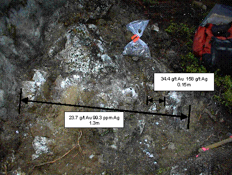
Zone 7 vein showing results of sampling across full width, plus section of intense quartz-siderite stockwork
(140o/90o).
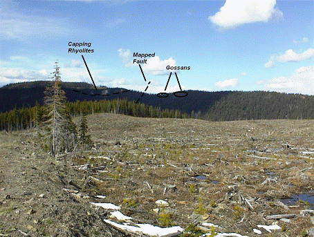
View to northeast across Boul 5 claim towards felsic volcanic rocks of the Eocene Penticton Group and the Siwash occurrence
(beyond the gossans on the far ridge). Bouleau Creek flows from left to right through the valley beyond the clearcut in the
foreground.